


de Lavialle à Mandailles st julien

CASSISFRAMBOISE
User
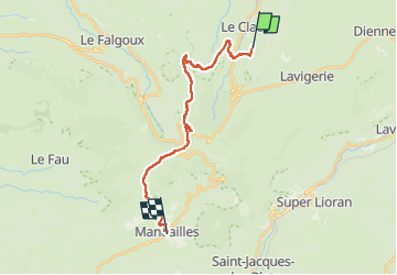

Length
19.9 km

Max alt
1729 m

Uphill gradient
953 m
Km-Effort
33 km

Min alt
922 m

Downhill gradient
1131 m
Boucle
No
Creation date :
2024-12-06 19:13:03.994
Updated on :
2024-12-06 19:14:37.251
7h32
Difficulty : Very difficult

FREE GPS app for hiking
 SityTrail
IGN / Geographical institutes
SityTrail Plus
The world is yours!
About
Trail Walking of 19.9 km to be discovered at Auvergne-Rhône-Alpes, Cantal, Le Claux. This trail is proposed by CASSISFRAMBOISE.
Positioning
Country:
France
Region :
Auvergne-Rhône-Alpes
Department/Province :
Cantal
Municipality :
Le Claux
Location:
Unknown
Start:(Dec)
Start:(UTM)
477236 ; 4999792 (31T) N.
Comments